Africa Map Quiz
Printable Africa Handout Quiz
What is our Africa Map Quiz Handout?
A ready-made quiz to print from a PDF onto an A4 sheet of paper. This one tests your knowledge of Africa and particularly the location of African countries on the map of Africa. There are 22 questions: 18 on African map geography and 4 additional questions. Perfect for an instant quiz. Great for a school or kids quiz about Africa.
Download and print a ready-made Africa Map quiz!
 There's two PDF documents available for this quiz. The first, is the map questions sheet. The second sheet has the answers. Both sheets are printed out with normal potrait mode printer settings.
Africa Geography Quiz Sheet: AFRICA MAP QUIZ PDF
Answer Sheet: ANSWERS PDF
NOTE: Every quiz is designed to use just one sheet of A4 paper. Most of our quizzes use potrait settings which your printer will normally be set to by default.
How to print?
Open your PDF document. Select the icon on the toolbar. From the menu bar select File and choose Print. Within the Print the current PDF document dialog box, select your paper printer using the drop-down menu.
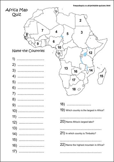
Some of the countries we ask you to identify on the map?
Tunisia, Sudan, Chad, South Africa, Ivory Coast, Cameroon, Mozambique and Kenya. Also, additional questions include: Which is the highest mountain in Africa? Name the largest country in Africa?